|
|
Airport/Aviation Facilities |
Airport Description
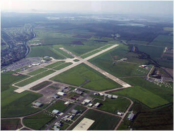 Photo taken shortly after Runway 18//36 Reconstruction - 2006
Houma-Terrebonne Airport (KHUM) is a General Aviation Airport
- Reference Point - Latitude N 29˚ 34’ 02.65”, Longitude W 90˚ 39’ 37.27”.
- Two intersecting concrete intersecting runways -
- Runway 18/36 - North-South Runway – 6,508 feet long by 150 feet wide – Full Instrument Landing System.
- Runway 12/30 – Crosswind Runway – 5,000 feet long by 200 feet wide – non-precision approach.
- FAA publishes six instrument approach procedures for the airport.
- Frequency radio communication: Ground 121.8 – ATIS 120.25 – Tibby Vortac 112.0 – ILS 108.5.
- AWOS frequency is 120.250 MHZ, phone number is 985-876-4055 – current weather conditions available on the airport 24 hours a day.

Photo taken by HTAC Field Personnel at Sunset
|
On Site Control Tower
|
Fixed Base Operators
There are three (3) fixed operators at HUM offering various services including fueling (AvGas and Jet), maintenance, parking, air charter and rental car services.
Apex Jet Center, LLC |
Hammonds Air Service, Inc. |
Houma Avionics, Inc.
|
Helicopter Operators
The Houma-Terrebonne Airport is host to helicopter operators shuttling crews out to oil rigs in the Gulf of Mexico.
Era Helicopters, LLC
|
PHI Aviation, LLC |
Westwind Helicopters, Inc.
|
